
Weather service under scrutiny over Texas flood forecasts
Early on Thursday, July 3, the National Weather Service issued a forecast that was hardly unusual or alarming for summertime in south central Texas. Meteorologists expected “scattered showers and thunderstorms,” with a chance for heavy rain and “isolated flooding.”
More than 20 hours passed before the forecast turned ominous.
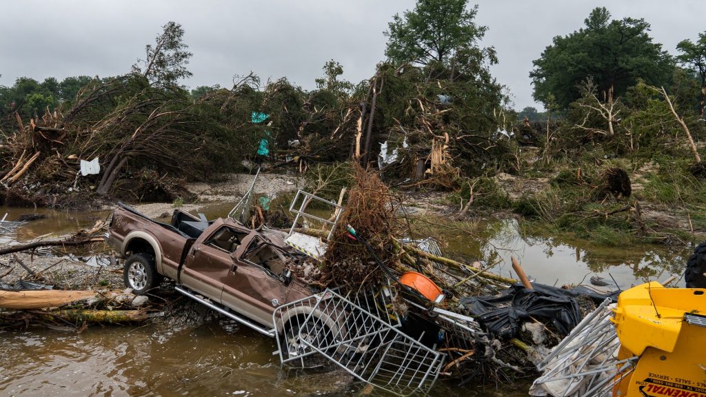
That gap calls into question the weather service’s performance in foreseeing the deadly flash flooding that washed through the Texas Hill Country over the July 4 holiday weekend. More than 100 people died, among them two dozen children swept away from their summer camp. About 40 people remain unaccounted for.
With the rescue effort continuing, federal, state and local officials are demanding answers about why the weather service did not issue more robust warnings before it was too late for mass evacuations. Did forecasters simply misjudge the severity of the storm? Or did staffing cuts at the weather service diminish the agency’s ability to predict the storm’s devastating potential and coordinate efforts to move residents to higher ground?
Democratic lawmakers have called for investigations into the flood forecasting.
In a statement to Straight Arrow News, Erica Grow Cei, a weather service spokeswoman, said extra forecasters were on duty in both San Angelo and San Antonio before and during the flooding.
“All forecasts and warnings were issued in a timely manner,” Cei said. “Additionally, these offices were able to provide decision support services to local partners, including those in the emergency management community. The NWS remains dedicated to our mission to serve the American public through our forecasts and decision support services.”
‘Locally heavy downpours’ in the forecast
Unbiased. Straight Facts.TM
The NWS issued the first flash flood warning for south-central Texas at 2:14 a.m. July 4. By about 6:30 a.m., the Guadalupe River had surged from 2 feet to 34 feet deep.

All day Thursday, as a tropical storm that originated in the Pacific Ocean fed saturated air across parts of Texas, regular forecasts and additional statements from the weather service gave little hint of the dangers awaiting a region known as “flash flood alley.”
At 1:06 p.m. Thursday, the weather service noted on social media that showers were increasing as humid, tropical air pushed into the area. “Locally heavy downpours” were possible, a post said.
Even the first suggestion of dangerous weather, issued at 3:35 p.m., signaled little urgency. The weather service issued a flash flood watch, saying 1 to 3 inches of rain could fall but that forecasters “can’t rule out” 5 to 7 inches in isolated areas.
“Excessive runoff may result in flooding of low-lying areas, rivers/creeks and low water crossing,” the weather service wrote on X.
Later posts noted more widespread rain across the Hill Country. Those posts warned about “torrential rainfall” in places that could cause ponding on roads.
More serious statements didn’t come until the overnight hours.
At 1:27 a.m. Friday, the weather service’s national Weather Prediction Center wrote on its website: “Flash flooding likely overnight with significant impacts possible.” The post said flooding could be significant, “especially considering sensitive terrain over portions of this region.” Still, forecasters said they expected no more than 6 inches of rain.
The weather service declared its first flash flood warning at 2:14 a.m., and at 3:37, it announced that “locally heavy rains are possible and may cause flooding this morning.”
The warnings became increasingly dire as dawn approached:
4:06 a.m.: “A very dangerous flash flooding event is ongoing across south-central Kerr County into northwest Bandera County, where 3-7 inches of rainfall has occurred in the last 2-3 hours. Heavy rainfall continues in this area and a Flash Flood Warning is in effect. Turn Around, Don’t Drown!”
5:23 a.m.: “A swath of 5-10” of rainfall has been estimated the last 3-67 hours across south-central Kerr County. This is a PARTICULARLY DANGEROUS SITUATION and a Flash Flood EMERGENCY is in effect.” The weather service would later tell NPR the language was “exceedingly rare” and was meant to convey “a severe threat to human life and catastrophic damage.”
6:08 a.m.: “Guadalupe River at Hunt continues to rise sharply and has reached 2nd highest height on record, higher even than the 1987 flood. This flood wave will continue through Kerrville & Comfort. This is a very dangerous and life-threatening flood event along the river. Move to higher ground!”
At that moment, the Guadalupe was surging from 2 feet to 34 feet at Kerrville, according to the U.S. Geological Survey. Dozens of people had already been swept away by the raging currents. They included 27 children and counselors from the century-old Camp Mystic on the river’s edge.
‘A national tragedy’


The weather service offices in San Angelo and San Antonio had “significant vacancies” in staffing, The New York Times reported. The Times cited an official of the union that represents weather service employees.
Vacancies in San Angelo include the meteorologist in charge, a senior hydrologist and a staff forecaster. At San Antonio, the warning coordination meteorologist, whose job was to work with local emergency planners on alerting and evacuating residents during floods, left work April 30 after accepting an early retirement package from the Trump administration, according to the Times.
“You have to have a response mechanism that involves local officials,” Louis W. Uccellini, a former weather service director, told the Times. “It involves a relationship with the emergency management community, at every level.”
Hundreds of weather service employees took early retirement, and the administration imposed a hiring freeze at federal agencies. However, the weather service says it is working to hire 126 new employees in offices around the country.
On Monday, July 7, Senate Minority Leader Chuck Schumer called for an investigation into “the scope, breadth, and ramification of whether staffing shortages at key National Weather Service stations contributed to the catastrophic loss of life and property during the deadly flooding.”
“This is a national tragedy which people across the country are mourning,” Schumer wrote to the inspector general of the Commerce Department, which oversees the weather service. “The American people deserve answers.”


